
Are you aware that how our daily lives are continuously driven by maps? Where are you at this moment? Where you intend to be in the next moment? How to get there? Where is the location of your destination? Or which are the areas you tread very often? Businesses are continuously capturing these data through locational analytics with maps also referred to as the power of where.
Maps are really the friends in need forming the base of defining the power of where. The transformation of static maps to dynamic digital models; with continuous up-gradation on the real-time basis to serve mankind is simply flabbergasting. Furthermore, with the use of Arc GIS, you can design your own maps using geographical information in electronic mode.
Arc GIS – the basic platform for displaying the power of where:
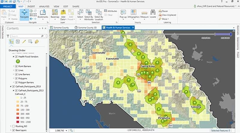 Image Source : desktop.arcgis.com
Arc GIS is a desktop mapping and spatial data probe application. It is built on a complex program and the users are guided to the precise direction that he desires to explore. Knowledge of Microsoft Windows is required to handle the application tools.
The application operates employing the theory of Geographic information system (GIS). It helps create maps where each breed of the spatial feature is a separate layer registered spatially. When the users spread them atop layer by layer, programs are perfectly aligned to create a perfect map.
It is really an amazing set of programs where mapping a location is possible with enough field constants codified geographically. Once numbers for latitude and longitude measures are provided, mapping spatially referenced data files in a spreadsheet is achievable.
Users have the option to set up a non-registered raster image. Power of where has interesting uses. With the help of geo-reference, they can set up vector features from a raster image. It is also possible to add further information of user’s choice to features. For achieving this, the user needs to be conversant with suitable writing and drawing kits. Importance of spatial analysis in GIS is evident from its multifarious applications.
Emphasizing the Power of maps:
 Historically, maps had been with us since evolution of humankind. Modern cartography has been through several landmark achievements. GIS experts have taken cartographic technology to a whole new dimension of excellence. Wide and in-depth application of modern mapping has embraced following areas:
- GPS and remote sensing
- Worldwide proliferation of big data
- Application of internet and web mapping services; these services have hugely subscribed towards growth, development and use of GIS and cartographic science in more than one ways.
Power of where is best felt while discussing areas of application of modern satellite based mapping tricks. Here we go with a few live examples:
Maps and Governance:
 GIS based mapping helps improve efficiency and speed of government working procedures. Governments can improve their quality of services to citizens with an emphasis on speed and perfection. Precisely designed accurate maps gives the government the necessary vision supported by significant inputs. The procedure finds ready application in:

- Emergency and disaster management
- Evaluation of infrastructure
- Military strategy implementation
- Better planning and use of land, roads and utility maintenance
- Urban planning
- Water quality management
- Assessment of natural resources like course of rivers, harnessing potential of waterfalls, mineral quarries etc.
Maps in business:
 Today business houses are collecting data at a frantic pace for survival. Money is being spent like water for retrieving significant information, which would out run the competitor’s performance. Importance of spatial analysis in GIS is plainly substantiated when we learn 80% of business house data has spatial constituents.
Experts reveal around 2.5 quintillion bytes of business data are generated every day. In this feverishly data driven business race, spatial analysis extends high potential ‘where point of view’ and ‘ conditional acumen’ facilities. Capability to envisage the ‘ where’ element is a crucial feedback for strategic planning. It eventually boils down to effective business solutions and intelligence.
Maps for citizens:
 Power of where is well manifested in our everyday use when common man gets help from spatial mapping. Maps help create a convenient, safer and blissful world around us. Some significant mapping applications that support citizens’ requirements are:
- Identification of threats like incidence of malignant tumors in residents staying near an acid plant.
- Early warning signals for impending catastrophe, an earthquake, for example.
- Helps healthcare professionals in locating regional factors having a bearing on the health of locals. Accordingly, medical solutions can be worked out.
Maps in civil and military applications:
 Image Source : lh3.googleusercontent.com
The power of maps can be seen in these areas as well. Maps have strategic importance and many countries treat their maps as secret documents. Just see for yourself how interesting and informative ‘ Google Earth ‘ and ‘ Wikimapia’ are. 24 x 7 satellite data feeds us with real-time information. Familiar applications include:
- Tracking your consignment
- Guiding self driving vehicles
- Visualization of amplified reality by remote sensing satellites
Spatial analysis giving a better insight of the Power of where:
 Whenever we come across a map; we try to dig out the related information by assessing its content, which helps in our decision-making. For example, analyzing the crime rate in a city, its transportation system or the location of schools and entertainment parks all play in our minds, which can be summarized as spatial analysis.
Application of spatial analysis helps merge sets of information from multiple sources. It results in synthesis of radically new set of information using state-of-the-art spatial analytical tools. It also involves the use of Arc GIS tools to address some critical points beyond our visual analysis.
The power of where is an all pervasive trend affecting every phase of regular life. Positional analysis is on a constant hunt for addresses, zip codes, service routes, street networks and important landmarks. Every desktop and mobile app is thriving on the significance of location.
Spatial analysis and mapping bring out the power of where in a clear and comprehensive portrait. You get to visualize the entire planet with oceans, elevations, dark spots, lighter spots with varied topographic depths.
Countries scattered across the globe with different business models and military strategies flex their muscles to rule the world. The mapping interpretation helps maintain international equilibrium where no one is allowed to display the ugly face of dictatorship.