
With the concerns of global warming , changing climatic patterns and unpredictable forecasts of weather, NASA seems to have come to the rescue. They have discovered means to predict emerging hurricane’s strength by monitoring the lightning strikes near a hurricane’s eye. The best part of this is that it can be done weeks before the storm arrives with the help of ‘highly-sensitive sensors’ that too located thousands of miles from the storm.
How can a hurricanes strength be predicted?
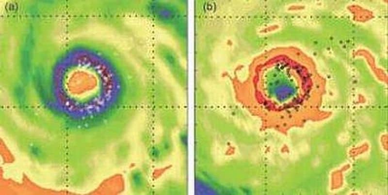
Researchers can now investigate with greater accuracy how the rate of lightning strikes produced within a hurricane’s eyewall is tied to the changing strength of that hurricane. A hurricane’s eyewall is the inner heat-driven region of the storm that surrounds the ‘eye’ where the most intense rainfall and most powerful winds occur.
By monitoring the intensity of lightning near a hurricane’s eye, scientists will be able to improve their forecasts of when a storm will unleash its harshest conditions. There are very few observing systems that offer a broad view of a storm over the open ocean where hurricanes tend to build or lose strength.
In NASA own words:
When water condenses from vapor into a cloud droplet, latent or hidden heat is released, which in turn builds updrafts — air moving upwards in a cloud. Latent heat provides the energy that fuels hurricanes. If the ensuing updrafts are strong enough, they can cause the separation of charge that produces lightning. The tight correlation between the rate of lightning strikes, the amount of rainfall and the heat released in the eyewall of a storm allows the lightning rate data to be useful in computer models that forecast hurricane track and intensity.
Better insights can help in many ways
Hurricanes are one of the most powerful storms on Earth, frequent and intense hurricanes, storms have become a recurrence these days, any information that can provide insight into saving future lives is most welcome. The unprecedented back-to-back blow of two Category 5 hurricanes, Hurricane Felix and Hurricane Dean, left many dead and numerous lives torn apart. We can only hope that this research is truly helpful in when future hurricanes strike.
Other speculations on hurricanes made by experts
Deadly hurricanes’ paths set by high-pressure systems, not global warming: Experts
When it comes to roaring up hurricanes and the nature’s furies, global warming is to be blamed straightaway, making no much effort to ponder on it. Despite, global warming and climate change being the present day ‘buzzword’ that is believed to spawn stronger tropical cyclones, experts do not seem to be ready to blame it all on any of the two without further investigating on the matter.
The year 2007 was considered as the hurricane season as a consequence of global warming, scientists are not ready to blame it straightaway on climate change – they are trying to stay pragmatic with their outlook and reasoning. Moreover, they were also checking various other aspects to predict emerging hurricane’s strength
The unprecedented back-to-back punch of two Category 5 hurricanes, Hurricane Felix and Hurricane Dean, in the same season that occurred for the first time on record, may have led many to making assumptions towards global warming impact – but, climatologists has warned them against.
Kerry Emanuel, a Massachusetts Institute of Technology professor of meteorology said,
My guess is that the high intensities of Dean and Felix had more to do with when and where they formed and tracked than with global warming per se.
So, while on one hand, the two maximum-strength hurricanes could be an evidence of climate change impact, a persistent high pressure weather system’s — usually located further northeast around Bermuda – leading to both the Dean’s and Felix’s formation can’t be ruled out or ignored.
Scientists hawk rising sea surface temperatures to predict hurricanes
People living on the hurricane-prone coastal zones are now living with their hearts in their mouths since the devastating and killer tropical cyclones are predicted for the prevailing months this year. Though always alert bout an approaching storm or cyclone, they surely need their gazing crystallized. Cuing up with these worries, the NASA scientists are keeping eyes for any forthcoming hurricanes. They are also looking at ways to predict emerging hurricane’s strength.
They are keeping a watch on the sea surfaces, rather their temperatures – the key element leading to the formation of tropical cyclones. And, the surfaces in the Gulf of Mexico, Caribbean and eastern Atlantic Ocean are found to be warming up by the middle of August!
The surface temperatures of the Gulf of Mexico seas were all found to be over 80 degrees Fahrenheit — which or even warmer seas can trigger tropical depressions to form tropical storms, eventually growing them into hurricanes.
This natural annual warming of the seas contributes to the possible formation of hurricanes in the Gulf.
To provide a breath of relief to the habitants of the hurricane-prone Gulf and the Atlantic, NASA’s Bill Patzert, oceanographer at the Jet Propulsion Laboratory, Pasadena, Calif. said,
The many Atlantic and Gulf citizens still reeling from the shock of the 2004 and 2005 Atlantic hurricane seasons, received some good news … the Atlantic sea surface temperatures that fuel hurricanes are somewhat cooler than the past few years. Based on this, some forecasters have reduced their forecasts. But the news is mixed.
So, most parts of the world’s population and resources especially that at the coastal areas, are at the mercy of the rising temperatures of the sea surface. If this is the case, the future has more in store for such nature’s devastating furies.
NOAA hurricane experts go airborne to promote Hurricane awareness at East Coast
Based on the elevated forecast for the 2007 hurricane season, the Atlantic Seaboard can be threatened by a devastating hurricane. People living within the region need to be made aware of the likely forthcoming calamities.
To raise such awareness, the NOAA hurricane experts are taking initiatives. They will be making a five-day, five-city tour of the East Coast aboard a NOAA WP-3 Orion turboprop Hurricane Hunter, beginning today.
Bill Proenza, the new director of the NOAA National Hurricane Center said,
Educating the public is our continuing mission. Even though last season had a below average number of tropical cyclones with no landfalling hurricanes, we remain in an active hurricane cycle likely to last another 10 to 20 years. Preparation through education is less costly than learning through tragedy.

Emergency management officials, non-profit organizations such as the American Red Cross and various local NOAA National Weather Service forecast offices will join the NOAA hurricane expert-team.
A break from seminars, papers and closed-door discussions, which are eventually irrelevant for the general mass, this NOAA team would invite public and media to not only tour the aircraft, but also speak with the delegation one-to-one.
James McFadden, PhD., chief of programs at the NOAA Aircraft Operations Center said,
We spend considerable time talking with children on the aircraft. If any of them take that message home to their parents, many more lives can be saved. This is a great way to teach hurricane awareness.
Though the hurricane season can’t be avoided and it’s devastations inevitable, such tours may help more people rescue or keep themselves away from the hurricane-related devastations.